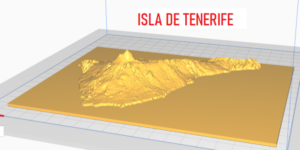
Print a 3D topographic map of the area of the world of your choice, when you have finished watching the video (just over 3 minutes), you will know how to do it perfectly and in a very simple way.
To clarify that there are other more sophisticated and more accurate procedures to make this type of models using programs such as QGIS and DEMto3D, along with digital elevation models (DEM) that can be downloaded, for example, from the download center of the National Geographic Institute, but this will be explained in another post.
´